Edward J. Gregr
B.Sc., Computer Science
(M.Sc. Candidate, Zoology)
Marine Mammal Research Unit,
Department of Zoology,
University of British Columbia,
Vancouver, British Columbia
Canada
Last modified 99.09.18
phone: 604.822.8181
email: gregr@zoology.ubc.ca |

|
"Common sense is not so common."
-Voltaire |
During better days (1992), when I actually
got out in the field! |
Interests
My interests are grounded in the problem of how space and time scales can
affect research results. A number of seminal papers are listed in the reference
list.
More specifically, I am interested in combining large, existing data
sets (historic records, remote sensing, etc.) and searching for hidden
or overlooked significance and correlation. I believe that while carefully
designed field experiments are necessary to answer specific questions,
the utility of the data collected far exceed the bounds of a single study.
I am interested in developing techniques to reuse existing data and to
explore potential relationships between historic datasets.
As part of what I've been doing the last 3 years, I've learnt alot about
the history of whaling, both in British Columbia,
and around the world. But the Pacific is my favorite ocean - maybe because
I've been staring a maps for so long!
Research
For my M.Sc. thesis, I am working with historic whaling records from coastal
whaling stations that operated in British Columbia, Canada between 1905
and 1967. My work is divided into two tasks:
-
an exploratory analysis of the whaling records in an
effort to identify any trends within the data, and
-
a habitat model based on the spatial distribution
of these historic records and oceanography.
Exploratory Analysis
This work, comprising the first chapter of my thesis, has recently been
accepted for publication in Marine Mammal Science pending some minor revisions.
I expect to get these revisions done before Christmas 1999 so I'm hoping
for publication sometime in early 2000.
Here's the abstract from the paper:
Gregr, Edward J., Linda Nichol, Andrew Trites, John Ford and Graeme
Ellis. 1999. Migration and population structure of Northeast Pacific whales
off coastal British Columbia: An analysis of commercial whaling records
from 1908-1967. Marine Mammal Science - accepted with revisions.
Migration and Population Structure abstract
Habitat Model
I am working feverishly to get this 2nd and final part of my thesis done.
Here's an example of the results, although it's all still very draft.
I in the process of trying to
explain these maps now. Coming soon.
Briefly, the maps are a prediction of Sei Whale habitat as a function
of depth and month. The "+"s are where whales were killed. Shading is from
white (probability of whales is zero, i.e. Pr(Wh)=0) to black where Pr(Wh)=1.
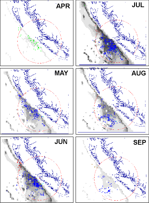
My second chapter will include probability plots like this for fin,
sei and sperm whales, and likely for humpbacks although the sample size
is much smaller.
Comments on the interpretations of these results are welcome!
Historical Whaling Database
Linda Nichol, Dr. John Ford and others worked hard years ago to compile
the historic whaling records for British Columbia waters.
We are currently working on a data report with DFO.
More soon!
Reference List
Seems there has to be something here ...